---------------------------------
Address
Phone: +251 988 111 222
Need help or have a question?
Contact us at: info@driveethiopia.com
Addis Ababa, Ethiopia
---------------------------------
Address
Phone: +251 988 111 222
Need help or have a question?
Contact us at: info@driveethiopia.com
Addis Ababa, Ethiopia


Whether the Danakil is safe, why heat is the real limit, what camp is actually like, what changed at Erta Ale in 2025, and what drives the cost.
The Danakil Depression sits about 125 metres below sea level in Ethiopia's Afar region, and the thing that limits a visit is heat rather than danger. The UK Foreign Office advises against all travel only to the parts of Afar within 10km of the Eritrean border, which is nowhere near Erta Ale, Dallol or the salt flats. The practical constraints are temperature, a four-day absence of infrastructure, and camping without running water.
This page covers what the trip involves, what conditions are actually like, what drives the cost, and what changed at the volcano recently.
Safety here splits into three separate questions that get answered as one, which is why the answers online contradict each other.
The government advisory. As of the FCDO update on 12 August 2026, the advice against all travel in Afar applies only within 10km of the Eritrean border. Erta Ale, Dallol, Lake Afdera and the salt flats all sit well outside that strip. Afar itself carries no blanket warning.
The neighbouring regions do. This is the part that catches people out. Tigray is under advice against all travel, and Mekele is in Tigray. Many Danakil itineraries have historically started or ended there. Amhara is also under advice against all travel. Approaching through Semera, which has an airport and is the Afar regional capital, avoids both.
If your operator proposes a route through Mekele, ask them directly about it. Travelling into a region your government advises against can invalidate travel insurance, which matters more here than almost anywhere, because this is a trip where a medical evacuation is a genuine possibility.
The environment. This is the real risk and it is the one people underestimate. See the next section.
Advisories change. Check the FCDO Ethiopia page yourself before you book rather than trusting any tour page, including this one, on a date-sensitive question.
Dallol holds the record for the highest average annual temperature of any inhabited place on Earth, at 34°C measured across 1960 to 1966. Daytime air temperatures routinely pass 50°C in the hot months.
That single fact governs the whole trip:
Practical heat precautions matter more than any other advice on this page. Drink continuously rather than when thirsty, take electrolyte salts and not only water, cover up rather than strip down, and tell your guide early if you stop sweating or get a headache. Heat exhaustion in a place four hours from a road is a serious problem.
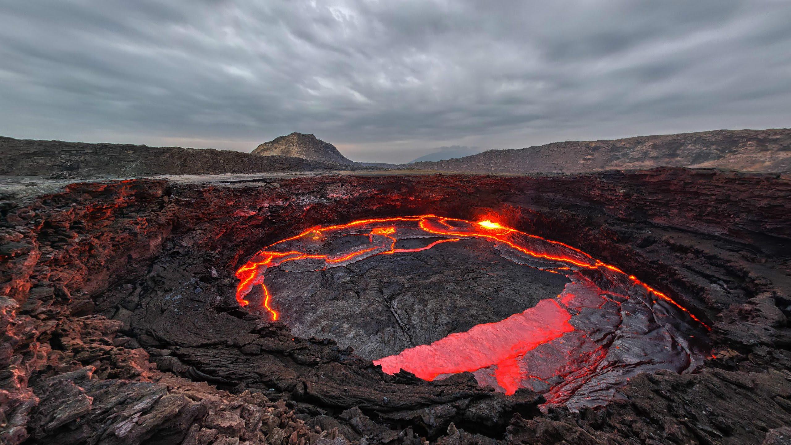
Erta Ale is one of the very few volcanoes on Earth that has held a long-term lava lake. The Smithsonian's Global Volcanism Program records the current eruption as ongoing since 1967, with at least one active lava lake in the summit caldera through that period.
What you see varies, and it changed recently. After the eruption at nearby Hayli Gubbi on 23 November 2025, satellite imagery two days later showed extensive ashfall across Erta Ale and a new collapsed area in the northern caldera, roughly 685 by 385 metres, southeast of the previously active pit craters. White plumes were rising from both pit craters.
So treat photographs of a full, glowing lava lake as a record of one visit rather than a description of yours. The volcano is genuinely active. Whether you look down at open lava on your night depends on the state of the crater at the time. Any operator promising a lava lake is promising something outside their control, and it is a fair question to put to them.
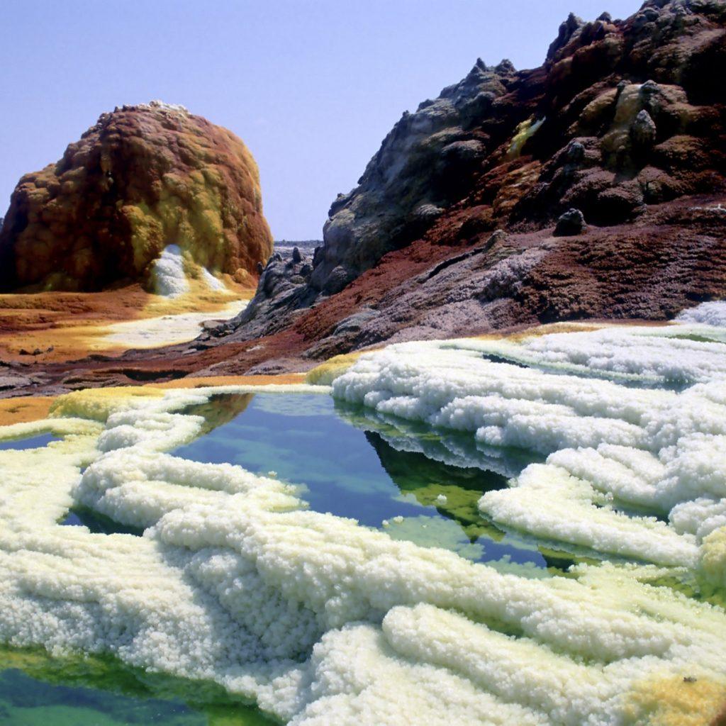
Dallol is a hydrothermal field of sulphur springs and mineral terraces in yellows, rust-reds and greens, sitting on top of a salt dome. The colours are the genuine article. The sulphur smell is strong and the ground in places is crusted acid pools, so this is a stay-behind-the-guide site rather than a wander-off one.
One thing worth correcting, because it circulates widely and this page carried it for a while: the Danakil is not the lowest place on Earth. It reaches about 125 metres below sea level. The Dead Sea shore is far lower, and Lake Assal in Djibouti, at about 155 metres below sea level, is the lowest point in Africa. The Danakil's real distinction is heat, not depth.
The salt flats near Lake Karum are where Afar communities cut and haul salt in blocks much as they have for generations, and where camel caravans still work. This tends to be the part people remember longest, ahead of the volcano.
Lake Afdera is a saltwater lake where the mineral content is high enough to float in without effort.

This is the shape of the trip, taken from our own account of running it.
| Day | Route | What happens |
|---|---|---|
| Day 1 | Fly Addis Ababa to Semera, then drive into Afar | Lake Afdera in the middle of the day, where Afar communities harvest salt. On to Erta Ale in the afternoon as the ground turns to volcanic rock. Ascend the volcano after dark and camp on the rim |
| Day 2 | Erta Ale to Dallol | Leave the volcano at first light. Cross to Dallol, the hydrothermal fields and mineral terraces. The salt lake where you float rather than swim |
| Day 3 | Salt flats, then out | Salt formations and salt pans, and the Afar salt-cutting that still works there. Depart in the afternoon and fly back to Addis Ababa in the evening |
Three days is the standard length. It is not a trip that rewards being shortened, because the driving is the bulk of it and the sights are spread across a wide area.
This is the part most tour pages skip, and it is the thing that most often surprises people.
There is no accommodation. You camp. On the volcano it is on the rim, and on the salt it is on the ground or on simple platform beds outdoors.
There is no running water. No showers for the duration. Water is carried in.
Toilets are whatever the site has, which is usually very basic or nothing at all.
Sleeping is outdoors and often on a mattress under the sky, because indoors is hotter than outdoors.
You travel in a convoy of 4x4s rather than a single vehicle, because the terrain and the remoteness make a single vehicle a bad idea.
None of that is a warning. People who know it in advance tend to have a good time, and people who expected a lodge do not. The trip is worth doing on its own terms; it is simply not a comfortable one, and an operator who implies otherwise is setting you up badly.
We do not publish prices, and we are not going to put an invented figure on this page. What is useful is knowing what a Danakil quote is actually made of, because it is a very different cost base from driving between towns in the highlands.
A convoy, not a car. Multiple 4x4s, fuel for a long distance with no stations.
Camping equipment and catering for the full duration, carried in, including all water.
Permits. The route requires them.
Local scouts. These are required rather than optional on this route, and they are a per-day cost.
Domestic flights at each end, unless you are driving from Addis Ababa, which adds days.
Days. Three days of vehicles, crew, fuel and food in a place with no infrastructure to buy anything from.
That combination is why the Danakil costs more per day than most Ethiopian itineraries, and why quotes vary so much: operators include different parts of it. When you compare two, check whether the flights, the permits and the scouts are inside or outside the number. Our guide to comparing tour quotes sets out the eight questions that matter.
November to February. The limit is heat rather than rain, and outside that window the route generally is not operating rather than merely being unpleasant. Our best time to visit guide covers how this fits with the rest of the country, and the comparison with Lalibela and the Simien Mountains is worth reading if you are choosing between them rather than doing all three.
It suits people who want to see active geology and do not mind being uncomfortable for three days. It suits photographers. It suits anyone who has wanted to look at a lava lake.
It does not suit anyone with a heart condition, anyone who struggles in heat, or anyone who needs a shower and a room at the end of a day. There is no soft version of this itinerary, and there is no way to shorten the drives.
If that reads as discouraging, it is not meant to. It is the information that decides whether you will enjoy it, and it is better to have it now than at 40°C on day two.
Is the Danakil Depression safe to visit?
The sites themselves carry no blanket travel warning. As of the FCDO update on 12 August 2026, the advice against all travel within Afar applies only within 10km of the Eritrean border, well away from Erta Ale, Dallol and the salt flats. The bigger considerations are that neighbouring Tigray, including Mekele, is under advice against all travel, and that heat is a genuine physical risk. Check the current advisory yourself before booking.
Why is the Danakil Depression so hot?
It sits about 125 metres below sea level in a low, enclosed rift basin with almost no vegetation, cloud or water to moderate temperature, over a geologically active zone where the crust is thin and spreading. Dallol holds the record for the highest average annual temperature of any inhabited place on Earth, at 34°C measured across 1960 to 1966.
Is the Danakil Depression the lowest place on Earth?
No. It reaches about 125 metres below sea level. The Dead Sea shore is considerably lower, and Lake Assal in Djibouti, at roughly 155 metres below sea level, is the lowest point in Africa. The Danakil's real record is temperature rather than depth.
Will I see lava at Erta Ale?
Possibly, but nobody can promise it. The Smithsonian's Global Volcanism Program records the eruption as ongoing since 1967 with a long-term lava lake in the summit caldera, so the volcano is genuinely active. However, following the nearby Hayli Gubbi eruption on 23 November 2025, imagery showed heavy ashfall across Erta Ale and a new collapsed area in the northern caldera. What is visible on any given night depends on the state of the crater.
How many days do you need for the Danakil Depression?
Three is the standard, and it is the shortest that works. The distances are long, the sights are spread out, and the volcano ascent has to happen at night. Cutting it shorter means spending proportionally more of the trip in a vehicle.
What is the accommodation like in the Danakil Depression?
There is none. You camp for the duration, on the volcano rim and on the salt flats, usually outdoors on a mattress or simple platform bed. There is no running water and no showers, and toilet facilities are very basic or absent. Water is carried in with the convoy.
What is the best time of year to visit the Danakil Depression?
November to February. The constraint is heat rather than rainfall, and outside that window operators generally do not run the route at all, so the question becomes availability rather than comfort.
Do you need a permit and a guide for the Danakil Depression?
Yes. The route requires permits, and local scouts are required rather than optional. It is not a destination you can drive into independently, and travel is by convoy of 4x4s rather than a single vehicle.
Conditions in the Danakil change more than anywhere else we operate. The volcano's crater has altered recently, the season is narrow, and the sensible route depends on what the advisories say the week you travel.
Tell us your dates and we will tell you what is running and what it involves, including the parts of it that are uncomfortable. We reply within a maximum of two hours, and you will have a detailed itinerary and a quote within 24 hours. The Danakil Depression tour is the itinerary this describes.
